")
")
ROMAN FRONTIER
![]()
This web site features some of the most remarkable cultural and historical sites of the ancient Roman heritage, united within the route “Roman Frontier within the Romania-Bulgaria Cross-border Region”. It is located in the easternmost parts of the European continent.
The backbone of the route winds along the lower Danube, which forms today a natural border between Romania and Bulgaria. The river once called Danubius (in Latin) was the northern border also of the Roman Empire. A powerful natural barrier, it served for protection and as a convenient trade route for providing supplies to the Roman legions.
For its time, Rome was the political, economic, cultural, religious and military centre of the world, and, thanks to the construction of a consolidated infrastructure, one of the largest empires in the history of the world existed for more than 2,000 years.
The Roman limes (a border defence or delimiting system of Ancient Rome) had a strong symbolic value. In the words of Greek writer and rhetorician Aelius Aristides who lived in the 2nd century AD, the borders of the empire were the membrane connecting many countries and they “encircled the whole civilized world.” The limes distinguished the great empire, a symbol of civilization and order, from the “barbarians” - a symbol of chaos, hazard as well as material and spiritual poverty.
During the existence of the Roman Empire, its limes was not permanently and continuously delineated. It served as a starting point for expanding into new territories with the purpose of generating new sources of income and for military campaigns. Its physical structure consisted of fortress walls, mounds, palisades, castella, castra and other types of forts. Bridges and front posts facilitated military operations and served as the basis for expansion.
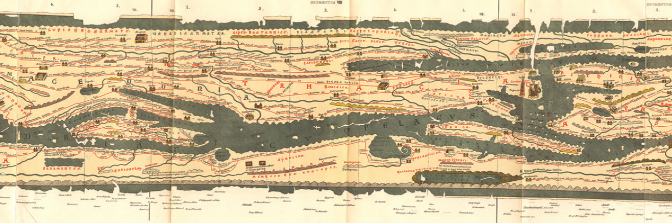
During the reign of Emperor Trajan (98-117), the limes of the Roman Empire reached its maximum length of more than 5,000 km. It extended from the Atlantic coast of Scotland across Europe to the Black Sea, continuing onto the Red Sea, passing through North Africa and reaching the Atlantic Ocean.
Out of all fortified borders of the Roman Empire, the most problematic were the ones along the River Rhine and the Danube as well as the eastern line. The northernborder was the longest and most difficult to manage, therefore the Danube limes had a largely protective function.
The Danube limes in Romania is 1075 km long and includes fortification systems, walls and earth, fortresses, towns and cities, settlements, structural elements of bridges and harbours. Some of the most distinctive archaeological sites of the Roman heritage are Drobeta (Mehedinti County), Sucidava (Olt County), Hinova (Mehedinti County), Capidava Carsium Troesmis Dinogetia (Constanta County).
The Roman limes in the Bulgarian lands is 471 km long, with its westernmost point being the mouth of the Timok River and its easternmost point - the town of Silistra. Among the most representative sites are Ulpia Oescus and Dimum (Pleven District); Nicopolis ad Istrum and Novae (Veliko Tarnovo District), Sexaginta Prista and Yatrus (Ruse District); Bononia (Vidin District); Durostorum and Transmariska (Silistra District).
The construction of the Danube limes began in the 1st century AD after the conquest of the Thracian lands lying between the Danube and the Balkan Mountains. It was in this period that the construction of the Danube limes started, consisting of military camps, settlements, observation towers and other facilities along the southern bank of the river. With the conquest of Dacia province (present-day Romania), the border shifted to the north. The newly conquered territories were included in the province of Moesia.
Favourable conditions were created for the development of agriculture, crafts and trade, as well as urban planning in Moesia.
In the late 3rd century, the rule of Rome in Dacia was overthrown. These events, as well as the invasions of the Goths, forced the central Roman power to take decisive measures in order to consolidate its Balkan territories. In connection with the administrative reform, the province of Dacia Ripensis was established, with its main city being Ratiaria (village of Archar).
In the late 3rd -early 4th century the Danubian limes was intensively restored and new strongholds were built at important strategic sites in the interior. The invasion of the Goths and Huns in the last quarter of the 4th century brought destruction to most of the fortresses. The Late Roman Empire began its decline by shrinking its borders which were “torn apart” by barbarian tribes and later destroyed. Some of the ancient fortresses continued to exist also during the Middle Ages.
The limes refers to a complex system of internal roads, fortification facilities, settlements and towns, specific terrains and anthropogenic interventions related to the cultural and technical organization of large areas.
FORTIFICATIONS: THE BASIS OF THE UNIQUE ROMAN DEFENSE SYSTEM ALONG THE DANUBE
The constant threat of attacks was the reason for the continuous construction of fortifications and strongholds in areas which remained under the control and supervision of the Roman army.
The first fortification activities of the ancient Romans began in the mid-1st century on the southern banks of the Danube in Oescus and Novae, and in the early 2nd century continued at Ratiaria (village of Archar), Ulpia Oescus (village of Gigen), Dimum (Belene), Sexaginta Prista (Ruse), Novae (Svishtov), Nicopolis ad Istrum (village of Nikyup). More than 40 fortresses have been discovered in the Bulgarian part of the limes, among them Almus (Lom), Augustae (Harlets village), Transmariska (Tutrakan), Nigrinianis-Candidiana (village of Malak Preslavets) and others. Four legion camps belonging to Lower Moesia have been partially studied - Ratiaria, Ulpia Oescus, Novae and Durostorum (Silistra). Important fortresses protecting the borders of Upper Moesia were Dorticum (village of Vrav, Vidin), Florentiana (village of Florentin, Vidin), Ad Malum (village of Koshava, Vidin), Bononia (Vidin), Remetodia (village of Orsoya, Montana), Pomodiana (village of Stanevo, Montana), Cebrus (village of Gorni Tsibar, Montana).
One of the longest fortification structures (235 km) was situated along the River Olt (Romania). Many observation towers were built along this defensive line. A 300-km-long fortification facility was the Brazda Lui Novac-North (Romania), which began in the vicinity of Drobeta, passed through Olt and ended in the vicinity of Pietroasele. Another wall, 170 km long, Brazda Lui Novac-South, closed the area from the north. To the west of Tomis (Constanta, Romania) was the starting point of consecutive fortifications guarding the access to central Dobrudja, reaching the Danube in the locality of Axiopolis (the so-called “Trajan’s Wall”).
ROADS: ONE OF THE FOREMOST ACHIEVEMENTS OF ANCIENT ROMAN CONSTRUCTION
The organization of the road system of Southeast Europe during the Antiquity was the work of the Romans. It was the roads that glorified Rome and remained the longest used facilities even after the decline of the Empire. They contributed not only to the development of trade, but also accelerated the cultural and technological exchange among the peoples living within the Empire.
Ever since the dawn of the Roman Empire, the inhabitants of the Eternal City realized the need to build roads serving for trade, communication, and, last but not least, for the movement of troops and the expansion of the Empire. Initially, older Thracian roads were used, but due to the different military organization, new roads started to be built on a grand scale.
Dozens of Roman roads crossed the territory of the Romanian-Bulgaria cross-border region. One of the most important was the Danube Road which started from Singingunum (Belgrade), passed through the settlements along the river and continued northeast to the Danube Delta, and thence continued along the Black Sea coast reaching Byzantium. Nowadays, some of the modern roads repeat its course.
Another major road linked Oescus (present-day village of Gigen) with the province of Thracia at the city of Philippopolis (Plovdiv), providing a direct connection between the Carpathians, Hemus, the Rhodope Mountains and the Aegean coast in almost a straight line.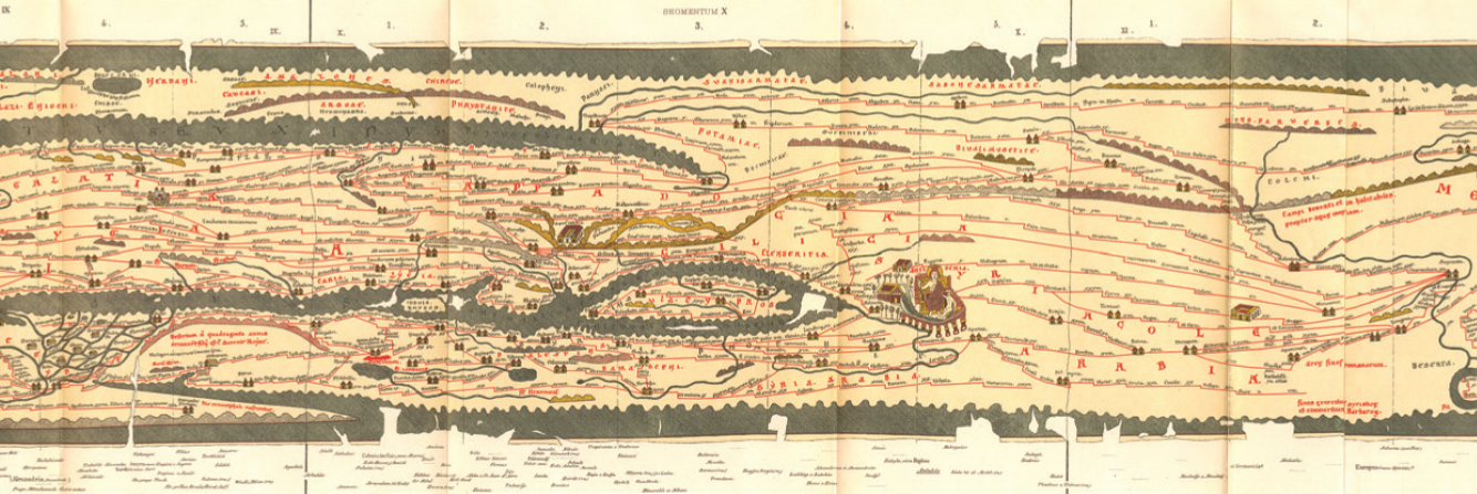
The road operated actively from the second half of the 1st century to the end-5th century, supported by a complex system of roadside facilities (stations, fortifications, satellite settlements, road branches, etc.). From Oescus the road splits into several directions.
BRIDGES ABOVE THE DANUBE: CONNECTION BETWEEN SHORES
The Ancient Romans built 8 bridges between the Iron Gates gorge and the Danube Delta.
The first bridge was built at the village of Dolni Vadin (Oryahovo Municipality, Bulgaria) and Orléa (Olt, Romania) by Emperor Domitian (81-96) during the Dacian war. Later, Emperor Trajan (98-117) built two wooden bridges on river ships, which served for transporting to the opposite bank of 200,000 people as well as military equipment and food supplies in the Loderata-Dierna section of the river and at the Iron Gates.
The most remarkable facility from this period was a bridge of stone and wood at Pontes-Drobeta (Turnu Severin) built between 102-105. The bridge was used for a long time for commercial and military purposes until it was intentionally destroyed by the Romans in order to ensure better protection.
Another stone-wooden bridge of major significance was built during the reign of Emperor Constantine the Great (306-337) between Ulpia Oescus (Gigen, Bulgaria) and Sucidava (Corabia, Romania). Wooden bridges were built also at Durostorum (Silistra) and near Bononia (Vidin).
DANUBE PORTS: MILITARY AND COMMERCIAL GATES OF THE EMPIRE
The Danube River was a navigable road for the Empire, with ports along its banks serving an entire fleet. The Empire possessed a huge and powerful infantry as well as the only fleet in the ancient world. The Roman fleet maintained a direct connection with the Straits and the Danube ports.
One of the largest ports of the Empire was Tomis (present-day Constanta, Romania). Historical sources contain reports of the movement of the imperial troops and rulers with ships along the Danube. The river fleet, divided into commercial and military, was actively used by emperors Domitian, Trajan, Constantine the Great, and Valent. Ports of importance were the ones at Ratiaria (village of Archar), Oescus (village of Gigen), Novae (Svishtov); Dimum (Belene), Sexaginta Prista (Ruse), Transmariska (Tutrakan).
ANCIENT SETTLEMENTS: MASTERPIECES OF ROMAN ARCHITECTURE
The technical facilities in the construction of which the Romans excelled are the water supply and sewer age systems of their settlements. Aqueducts were built, often combined with a viaduct, which brought water from the distance of tens of kilometres and were used for hundreds of years. The settlements were characterized by street networks, squares (forums), religious and public buildings (temples, basilicas, odeons, thermae, theatres), residential buildings, urban and country villas characterized the appearance of the settlements.
The most impressive buildings in terms of architectural and engineering complexity were the thermae (public baths). What strikes the most is their heating system of the water and the premises (hypocaust). The thermae were richly decorated on the interior and exterior with a variety of marble tiles, frescoes and mosaics.
The large-scale construction work of Emperor Trajan (98-117) consisted of the planning and construction of some of the most beautiful ancient cities. Several of them possessed the status of a colony - a city equal to the capital of the Roman Empire, namely: Ratiaria, Ulpia Oescus, Drobeta, Tomis.
THE PRESERVED ROMAN HERITAGE
There are few places having remained untouched by man in the 21st century. Ancient Roman sites are scattered along the Lower Danube, revealing the splendour of monumental complexes and beautiful buildings destroyed by the invasion of the northern tribes.
Few are the ancient settlements on which no modern cities have arisen: Ulpia Oescus (village of Gigen); Novae (Svishtov); Nicopolis ad Istrum (Nikyup); Ratiaria (village of Archar); Tropaeum Traiani (Adamclisi), etc. They give a real idea of the layout and scale of a Roman city, although they are still under exploration.
Remarkable are the remains of Roman fortresses: partially preserved walls of Bononia (Vidin); Castra Martis (Kula); Sucidava (Corabia); Capidava (Romania) and others.
It is only in Romania at Drobeta-Turnu Severin and in Corabia that one can still see ruins of the majestic bridges of Emperors Trajan and Constantine the Great - a testimony to the power of one of Europe’s most ancient civilizations. The wealth of the Northern provinces is evident in the many artefacts preserved in historical museums. Capitаls of exquisite craftsmanship are stored in Ratiaria, Ulpia Oescus, Nicopolis ad Istrum and Durostorum. Beautiful ceiling cassettes made of stone are preserved in Ulpia Oescus and Nicopolis ad Istrum. Inscriptions on marble and stone tell of the millennial grandeur of the Roman Empire and the lives of the local inhabitants.
Statues of the deities of the Greek and Roman pantheon have been uncovered, often representing Roman copies of ancient Greek compositions (“Hercules Resting” from Ratiaria - a copy of Lysippos’s original work, “The Resting Satyr” from Ad Putea, “Eros” from Nicopolis ad Istrum - a copy of Praxiteles, Statue of Fortuna from Ulpia Oescus, etc.). Tombstones and dedication plates also belong to the Roman cultural heritage.
A wonderful illustration of the painting styles, used mainly in the rich Roman urban and country villas, in the public and religious buildings and tombs is the ancient Roman tomb in Silistra.
Unique floor mosaics from the ancient cities of Ratiaria, Ulpia Oescus, Tomis and others. Outstanding artefacts keep alive the memory of the thriving empire.There were also remarkable architectural achievements of the ancient civilization which subsequently suffered a decline as these artefacts were destroyed by the invasion of the northern tribes.
ROUTE “ROMAN FRONTIER WITHIN THE ROMANIA-BULGARIA CROSS-BORDER REGION”
It combines a cultural and historical route with a tourist destination. It includes sites in Romania and Bulgaria - synchronously connected and originally part of the Roman heritage. The authenticity and the connection between the sites is a reflection of historical memory, not an arbitrary manifestation of time.
The route is a bridge between cultural identity, diversity, dialogue, tolerance and understanding in the contemporary context of a united Europe and an increasingly globalized world.
It is situated in the temperate climate zone, with four distinct seasons and a relatively mild climate compared to Central, Eastern and Northern Europe. This is a prerequisite for the development of this cross-border region as a year-round tourist destination.
The region has more than 4.7 million inhabitants. The main languages spoken here are Bulgarian and Romanian.